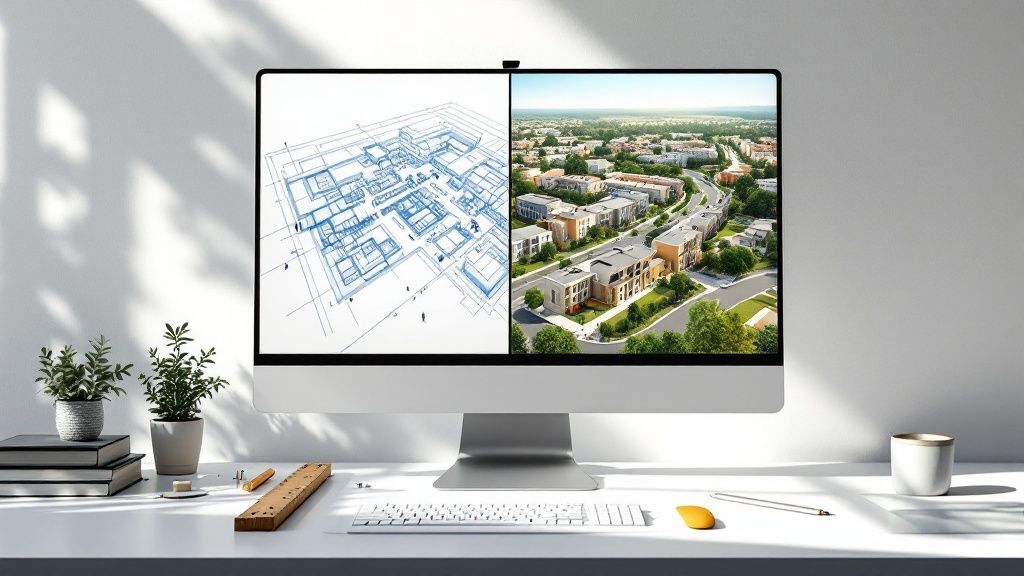
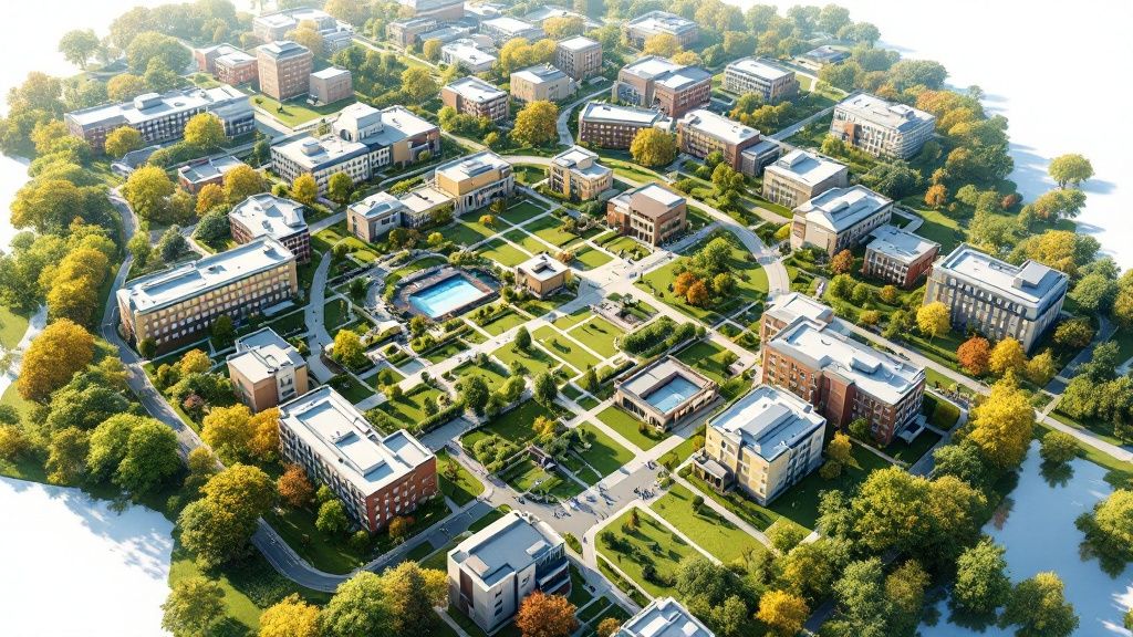
Ever looked at a complex blueprint for a massive new development and felt completely lost? You're not alone. That's where a master plan rendering comes in. Think of it as the ultimate preview—a stunning, photorealistic vision of a huge project like a university campus, a new city centre, or a sprawling industrial park.
It’s far more than just a map. It’s a 3D story, showing exactly how new buildings, parks, roads, and public spaces will all fit together and feel, long before a single shovel hits the ground. It takes all that dense, technical data and turns it into a vision everyone can get behind.
Bringing Ambitious Blueprints to Life
Imagine trying to pitch a high-tech business park to investors using nothing but zoning documents and architectural drawings. For most people—including city officials and the public—those flat, 2D plans are hard to get excited about. This is precisely why a master plan rendering is so crucial. It acts as a universal translator, turning abstract concepts into a tangible, visual story that makes perfect sense.
Instead of just showing property lines and dimensions, a rendering brings the experience of the place to life. You can see how sunlight will hit the buildings, how people will move through the green spaces, and what the overall vibe of the community will be. This kind of visual storytelling is absolutely essential for getting approvals and building public support for major developments.
More Than Just a Pretty Picture
It's easy to dismiss these renderings as just marketing fluff, but that's a huge misconception. They're actually powerful strategic tools. Architects and planners use them to spot potential design flaws early on, experiment with different layouts, and perfect the flow between things like transport links and residential areas.
Now, you might be thinking this sounds a lot like visualising any other building project. While the tools are similar, the focus is completely different. A master plan is all about the big picture—the complex web of infrastructure and zoning that shapes an entire district. For a closer look at how this differs from smaller-scale visuals, check out our guide on site plan rendering, which dives into the specifics of individual properties.
To make this clearer, let's break down what a master plan rendering actually visualises.
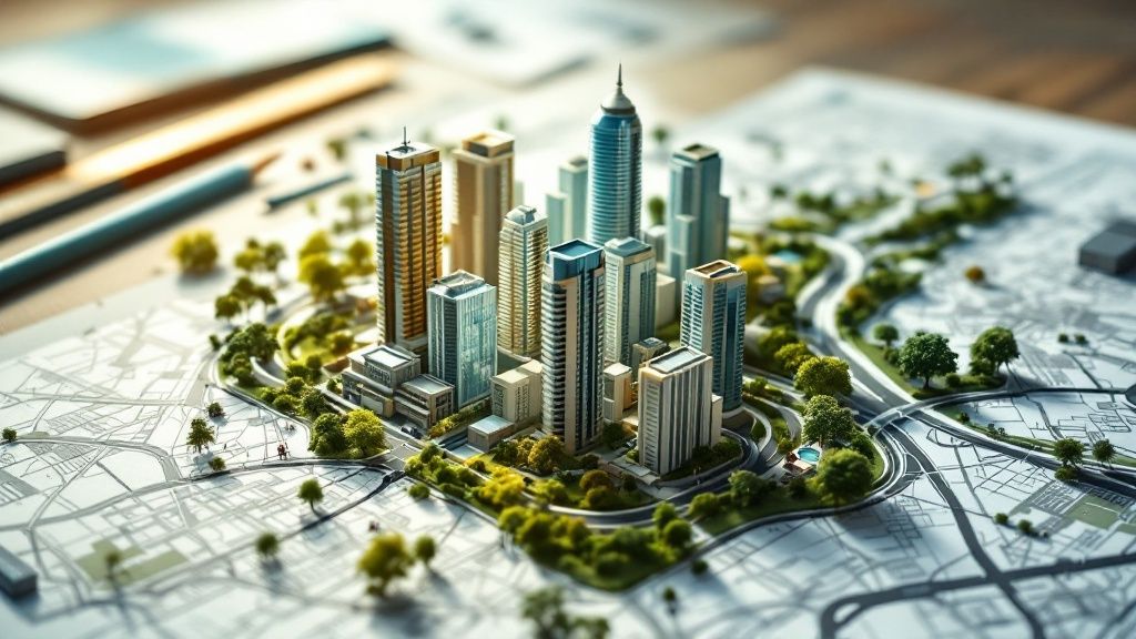
Key Components of a Master Plan Rendering
This table shows the essential elements that are brought to life in a comprehensive rendering.
| Element | What It Shows | Why It's Important |
|---|---|---|
| Buildings & Structures | The placement, scale, and architectural style of all buildings. | Establishes the visual character and density of the area. |
| Infrastructure | Roads, bridges, public transport routes, and utilities. | Shows how people and services will move through the development. |
| Public Spaces | Parks, plazas, waterfronts, and recreational areas. | Highlights the quality of life and community-focused aspects. |
| Landscaping | Trees, green belts, and natural features. | Illustrates the environmental design and aesthetic appeal. |
| Phasing | How the project will be built and developed over time. | Helps stakeholders understand the long-term vision and timeline. |
Seeing these elements together in a single, cohesive visual makes the entire project tangible and easier to evaluate.
A great master plan rendering does more than just illustrate a design; it builds consensus. It provides a shared vision that aligns the goals of developers, city planners, investors, and the community, turning a complex proposal into an achievable reality.
This kind of alignment is especially critical in fast-growing economies. In India, for example, the infrastructure sector is expanding rapidly, fuelling large-scale urban projects, with transport infrastructure making up a major share of that investment — a core part of any master plan.
For developers aiming to secure a piece of that investment, a compelling rendering is often the first and most important step. As noted by Mordor Intelligence, presenting a clear, persuasive vision is how you effectively communicate a project's value to the stakeholders shaping the future of India's cities.
How Visuals Are Reshaping Urban Planning in India
A great master plan rendering does more than just look pretty. It fundamentally changes how we plan our cities, especially in a country as dynamic and complex as India. These visuals slice through dense technical reports and bureaucratic jargon, presenting a clear, shared vision that anyone can instantly grasp.
Think about it. How do you get people excited about a multi-billion-rupee infrastructure project using only spreadsheets and dry policy documents? It’s nearly impossible. A rendering takes that abstract data and makes it tangible. Suddenly, a massive project feels real, accessible, and something to look forward to.
This is where the real value lies. It’s not about aesthetics; it’s about communication. A compelling visual becomes the common ground for everyone involved—from government agencies and private investors to the local communities who will live there.
Building Bridges and Attracting Investment
In urban planning, getting everyone on the same page can feel like the toughest part of the job. A master plan rendering acts as a universal language, closing the gap between engineers, politicians, financiers, and the general public.
When an investor sees a photorealistic vision of a future smart city or a new industrial hub, they aren't just looking at drawings. They're seeing a return on their investment. The visual story proves the project is viable and ambitious, making it a far more powerful pitch than any written proposal could ever be. This kind of clarity is what helps secure the private funding essential for India’s large-scale development.
These visuals are just as crucial for earning public trust. They show citizens exactly how a project will improve their lives—new parks, better transport, modern housing. When people can actually see the benefits, it’s much easier to build support and reduce the friction that so often stalls major initiatives.
A Unified Blueprint for National Growth
If you want a real-world example of this visual-first approach in action, look no further than the PM GatiShakti National Master Plan. This incredible initiative is designed to untangle infrastructure development across India by knocking down the walls between different government departments. Before, one ministry might build a road, only for another to dig it up a month later to lay cables.
GatiShakti puts an end to that by creating a single, visual platform where all infrastructure projects can be seen together. Planners can finally spot overlaps, identify potential conflicts, and find the most efficient routes. It’s a master plan for the entire country, coordinated through a shared visual map.
The impact has been massive. Since its launch, the plan has brought 57 Central Ministries/Departments and all 36 States/Union Territories onto one platform. It has helped review 293 infrastructure projects valued at a mind-boggling Rs. 13,59,000 crore (that’s about US$155 billion). You can get a sense of the scale of this project and its transformative impact on Indian infrastructure by reading more about it.
By making planning a visual and collaborative process, the government is preventing expensive mistakes and speeding up development. The key wins are clear:
-
Better Coordination: Ministries see each other’s plans in real-time, which means less redundant work and fewer delays.
-
Smarter Decisions: The platform uses geospatial data to make better choices about logistics, industrial zones, and transport networks.
-
Lower Costs: Finding and fixing problems before a single shovel hits the ground saves an enormous amount of public money.
What GatiShakti proves on a national level is the same thing we see on a local one: visualisation isn’t just a finishing touch. It’s a core strategic tool for smart, efficient, and successful development.
At the end of the day, whether you're planning a small township or an entire nation's infrastructure, turning the plan into a picture is the surest way to turn that vision into a reality. It gets people excited, secures the funding, and makes sure everyone is pulling in the same direction.
The Master Plan Rendering Workflow Explained
Ever wondered how a sprawling, complex urban plan goes from a stack of technical drawings to a stunning, lifelike vision? It's a fascinating journey that's part data science, part technical wizardry, and part pure artistry. Forget thinking of it as a simple production line; it's much more like crafting a bespoke film, where every scene and every detail builds on the last to tell a compelling story about the future.
And it all starts not with a mouse click, but with a massive data-gathering effort. This is the bedrock the entire visual narrative is built upon.
Stage 1: Assembling the Digital Canvas
Before a single 3D object is created, the team has to collect and make sense of a huge amount of information. This isn't just about getting the measurements right; it's about capturing the soul of the location. Think of it like a detective gathering clues to build a complete picture of the scene.
This initial research stage usually involves pulling together several key types of data:
-
Geospatial Data: This is the big-picture stuff. High-resolution satellite imagery, detailed topographical surveys, and GIS (Geographic Information System) data. This information forms the base layer of the digital world, ensuring every hill and valley is exactly where it should be.
-
Architectural Plans: Here's where we get the specifics. Detailed CAD drawings for every single proposed building, bridge, and piece of infrastructure are absolutely critical. These blueprints provide the precise geometry needed for the 3D models.
-
Contextual Information: Planners also gather photos and videos of the existing site, landscape surveys detailing the local plant life, and even traffic flow data. This kind of detail helps ground the rendering in reality and makes it feel truly authentic.
Once all this data is in hand, it’s layered together to create a comprehensive digital canvas of the project site. Getting this foundation right ensures the final rendering isn't just beautiful, but also geographically and architecturally spot-on.
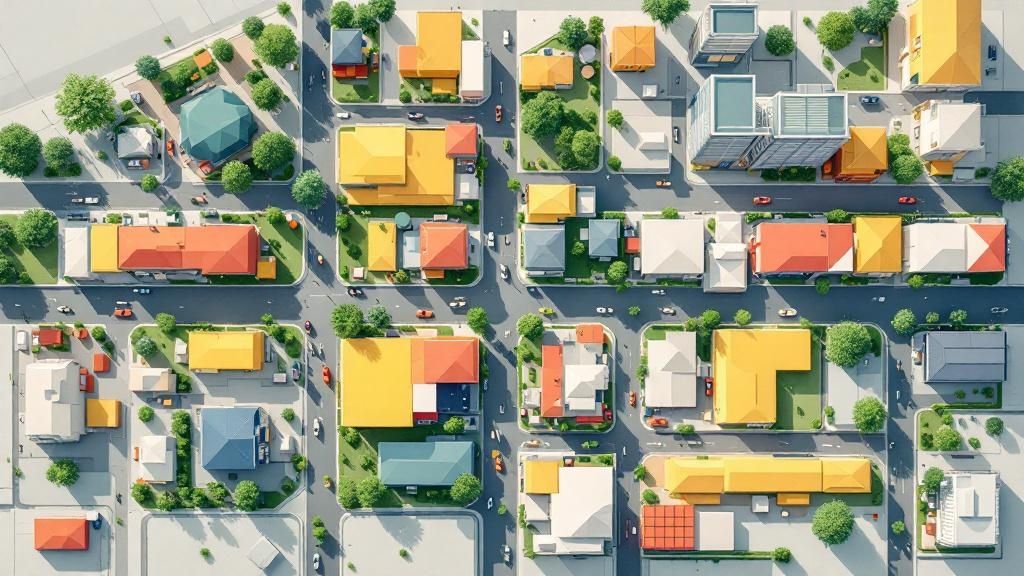
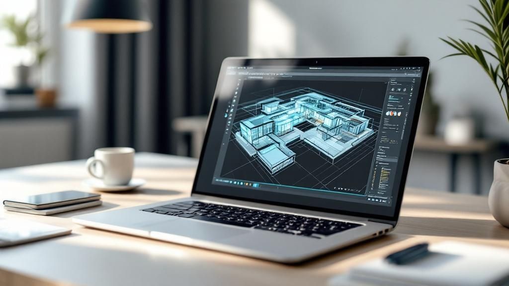
Stage 2: The Heart of Creation - 3D Modelling
With the foundational data in place, it’s time for the artists and technicians to get to work. This is where the flat plans and maps start to pop into three-dimensional form, building a digital city from the ground up. It’s an incredibly intricate process, a bit like a digital sculptor meticulously shaping every detail of a massive sculpture.
The team builds digital models for every single element—from the tallest skyscraper right down to the individual park benches and streetlights. Using powerful software, they construct the geometry of the buildings, lay out the road networks, and sculpt the landscape to match the master plan. This stage demands an unbelievable amount of attention to detail to make sure every part of the model is accurate and to scale.
A common misconception is that rendering is some automated, one-click process. In reality, the 3D modelling stage is a highly manual and creative job where artists make crucial decisions about form, scale, and composition that will define the final image.
The entire process follows a clear path, moving from a rough concept to a polished, realistic final image.
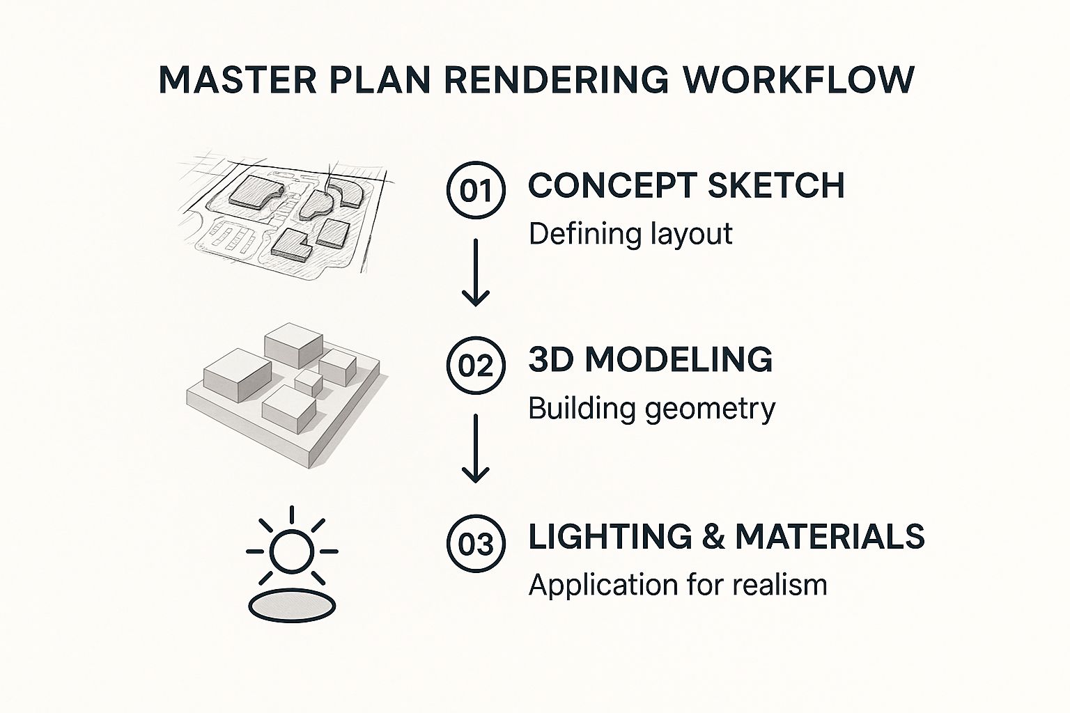
This visual breaks down how the workflow moves from simple sketches that define the layout to complex 3D models, and finally to the application of realistic lighting and materials that bring it all together.
Stage 3: Bringing the Vision to Life
This final stage is where the render comes together. The digital model is transformed into a photorealistic image through several steps that add depth, realism, and mood. If modelling is the sculpting, this stage is the painting and lighting.
-
Texturing and Materials: Artists "paint" every surface with digital textures. This is what makes a glass skyscraper look reflective, a brick wall appear coarse, and a grassy park look lush and inviting.
-
Lighting: This is perhaps the most crucial artistic element of all. The team sets up digital lights to simulate everything from the sun and streetlights to the glow from inside buildings. The quality of that light—whether it’s the warm glow of a sunset or the crisp light of midday—has a massive impact on the mood of the rendering.
-
Adding Entourage: To make the scene feel truly alive, artists add elements like digital people, cars, trees, and other landscaping. This "entourage" helps viewers understand the project's scale and imagine themselves walking through the space.
-
Rendering and Post-Production: Finally, the computer crunches all of this information to generate the final image—a process that can take hours or even days. Afterwards, artists often use software like Photoshop for colour correction, adding atmospheric effects like haze or lens flare, and making those last-minute tweaks to perfect the image. For a closer look at the technical side, you can explore our detailed guide on how to render in SketchUp and other platforms.
The Tools of the Trade: What Modern Rendering Artists Use
This kind of interface really shows where the industry is heading. Instead of wrestling with a thousand complex settings, artists can now use intuitive, AI-assisted tools to get stunning visuals out the door quickly. The focus has shifted to making powerful technology accessible.
Behind every jaw-dropping master plan rendering, there’s a whole suite of powerful software. Creating these huge, detailed visions isn't a one-and-done deal with a single program. It’s more like a digital assembly line, with specialised tools handling each part of the job.
Think of it as a workshop. You've got different tools for cutting the raw materials, assembling the frame, and then adding the finishing touches. The same principle applies here, starting with raw data and ending with something that looks breathtakingly real.
The Foundation: Data, Maps, and Plans
Before you can even think about building a 3D model, you need a solid foundation. This means creating a precise digital twin of the project's landscape and everything in it. This first step is all about accuracy and handling big chunks of data.
-
AutoCAD: This is the bedrock of the industry. It’s the go-to for creating or tidying up the initial 2D site plans, architectural drawings, and infrastructure layouts. It’s the digital drafting table where it all begins.
-
ArcGIS: When you're dealing with huge areas, you need a geographic information system (GIS). ArcGIS lets you layer all sorts of geospatial data—topography, zoning maps, existing utility lines—to build an intelligent map that becomes the base for everything else.
Getting this part right is non-negotiable. These tools make sure the final render is anchored in reality, with every road, tree, and building placed exactly where it should be.
Building the 3D World: Modelling and Rendering
With the 2D blueprint locked in, it’s time to go vertical. This is where artists take those flat plans and extrude them into 3D forms, then bring them to life with realistic textures, lighting, and a sense of atmosphere. The software you pick here really shapes the final look and feel of the image.
It's pretty common for artists to use a few different programs together. One might be great for the heavy-duty 3D modelling, while another excels at creating those beautiful, lifelike final touches. It's all about playing to each tool's strengths to get the best result.
If you’re interested in exploring the full range of options out there, we've put together a detailed guide on the best architectural rendering software that professionals rely on every day. It's this smart combination of powerful modelling and rendering engines that produces those truly spectacular visuals.
Making It Real: Interactive and Immersive Tools
A still image can tell a great story, but modern master plans often need to go further. Today, we can create interactive experiences that let clients and stakeholders walk through a development before a single shovel hits the ground.
-
Lumion & Twinmotion: These tools are brilliant for creating real-time animated fly-throughs. They give you a dynamic, fluid sense of what it would actually feel like to move through the space.
-
Vibe3D: For those who need to iterate and get feedback fast, Vibe3D uses AI to generate photorealistic visuals from 3D models quickly. You can make changes with simple text prompts and see a new render in seconds—useful for live client meetings.
This final, interactive layer turns a master plan from something you just look at into a place you can virtually step inside. It gives people a genuine sense of scale and presence, making the future vision feel incredibly real and within reach.
Creating Renders That Actually Make an Impact
It’s one thing to create a technically perfect master plan rendering. It's another thing entirely to create one that actually persuades people. I’ve seen incredibly skilled work fall completely flat because it lacked one crucial element: storytelling.
A render that truly makes an impact does more than just show what a development will look like; it makes stakeholders feel its potential. This is where the artistry of the craft meets cold, hard strategy. You're not just building an image; you're building a connection and answering unspoken questions through every choice you make in composition, lighting, and detail.
Crafting a Clear Visual Narrative
Before you even touch a single setting for lighting or start worrying about textures, you need a story. What’s the single most important message you need to get across? Is it the connected transport links? The family-friendly green spaces? Or the buzz of a new community hub? Every creative decision from here on out has to support that one core idea.
Think of yourself as a film director. You're setting a scene. The camera angle, the time of day, the types of people and activities you show—it all builds the narrative. An eye-level view, for instance, can give a really intimate, human-scale feel. In contrast, a big, sweeping aerial shot is perfect for highlighting the project's grand scale and how it connects to the wider area.
A great master plan render doesn't just present information; it guides the viewer's eye. It instinctively answers the "what's in it for me?" question for everyone involved, from an investor looking at profitability to a potential resident picturing their future life.
When you approach it this way, you end up with more than just a catalogue of buildings. You create a powerful piece of communication that gets people genuinely excited and helps build that all-important consensus.
Balancing Realism with an Aspirational Vision
Everyone wants photorealism, but it’s a tricky balancing act. The render needs to feel grounded and believable, but it also has to sell a dream—a slightly idealised, aspirational version of the future. The real trick is to sidestep that sterile, overly perfect look that just screams "fake."
It's the tiny details that truly sell the illusion and make a space feel authentic and lived-in.
-
Human-Scale Elements: You absolutely have to add people (what we call 'entourage'). Show them doing real things—walking their dogs, cycling, chatting at a café, or just relaxing in a park. This not only gives a sense of scale but also injects the scene with life and energy.
-
Realistic Landscaping: Don't just plonk a few generic trees down. Think about using native plant species, showing variety in the foliage, and even considering how the landscaping will look once it has matured. This kind of ecological detail adds a surprising amount of believability.
-
Subtle Imperfections: A perfectly spotless world just doesn't feel real. Adding tiny details like light weathering on a wall, a few fallen leaves on a path, or the soft glow from inside a window at dusk can make a scene feel infinitely more relatable. You can even bring these techniques indoors, as many 3ds Max interior design tutorials demonstrate when creating lived-in atmospheres.
All these little things work together to bridge that gap between a technical drawing and a genuinely emotional experience.
Thinking Ahead: Optimising for Different Platforms
Your master plan rendering is almost never going to live in just one place. That same core visual might need to be blown up for a huge print in a boardroom, shrunk down for a PowerPoint slide, posted on social media, or even turned into an immersive VR walkthrough. Each of these uses has its own rules.
-
For Print: High resolution is king. The image has to be razor-sharp, even when it's printed at a massive size. Every little detail is under scrutiny here.
-
For Digital Screens: Composition is the main game. How will the image crop on a wide desktop monitor versus a vertical phone screen? You need to make sure the key focal points are still clear, even when it’s viewed on a small device.
-
For Virtual Reality: This is a whole different ballgame. You’re not just making an image; you’re building a 360-degree world that needs to feel immersive and explorable from a first-person view.
By thinking about these final destinations right from the start, you’ll save yourself a world of pain later. It ensures your hard work makes the biggest possible impact, no matter where it ends up being seen.
From Digital Vision to Real-World Challenges
A stunning master plan rendering is a fantastic starting point. It paints a compelling picture of a future city, gets everyone excited, and helps secure initial buy-in. But let's be honest—the journey from that polished digital image to a living, breathing community is littered with obstacles, particularly in India's complex urban landscape.
The most beautiful render is useless if it can't actually be built. It’s one thing to design a perfect city on a computer, but it’s a whole different ball game to navigate the on-the-ground realities of land acquisition, political will, and tricky public-private partnerships. A truly successful master plan needs more than just a great design; it needs a rock-solid governance framework to turn that rendered dream into bricks and mortar.
The Gap Between Plan and Pavement
One of the biggest hurdles we consistently see is the chasm between a plan's ambition and the real-world ability to enforce it. Weak enforcement of development rules, bureaucratic red tape, and conflicting interests can slowly erode a grand vision until what gets built is barely recognisable.
Take the Jaipur Master Plan, for example. It’s a classic case study of this friction between technical goals and practical outcomes. The original proposal was to allocate a respectable 9.92% of the developed area for public or semi-public use.
But the reality on the ground tells a very different story. So far, only 4.48 square kilometres—just 2.12% of the developed area—has actually been set aside as recreational space. That’s a massive shortfall from the original 11.3% target for that specific category. To get a deeper sense of these challenges, you can explore the detailed findings of the Jaipur case study.
This isn't just a numbers game; it's about quality of life. When promised parks and public squares never appear, the whole community feels the loss. It’s a stark reminder that a plan is only as good as its execution.
Common Hurdles in Urban Implementation
The struggles in Jaipur are far from unique. Planners and developers all over India run into a similar set of roadblocks that can derail even the most carefully rendered master plan. Getting past them takes real foresight and some creative problem-solving.
Here are a few of the usual suspects:
-
Bureaucratic Delays: The process of acquiring land and getting all the necessary permits can be painstakingly slow. We're talking years, not months, which can cause projects to lose momentum and funding.
-
Conflicting Interests: A master plan has to walk a fine line between public sector goals and the profit motives of private developers. If these interests aren't aligned from day one, you’re setting the stage for conflicts that can stall progress indefinitely.
-
Lack of Public Participation: If the local community isn’t brought into the conversation early on, they can feel ignored. That can lead to resistance, protests, and legal battles down the road when the bulldozers show up.
-
Funding Gaps: Securing the huge, long-term investment needed for major urban development is a constant struggle. You might have the initial funding sorted, but gaps often appear as the project moves from one phase to the next.
This is where modern visualisation tools are starting to make a real difference. Immersive technologies, for instance, let stakeholders step inside a space before a single shovelful of dirt has been moved. Our guide on using virtual reality in interior design touches on how these tools create a much deeper, shared understanding—a principle that scales up perfectly to urban planning. By giving people a more tangible vision, planners can build a stronger consensus and navigate these challenges much more effectively.
Got Questions? We've Got Answers
If you're new to the world of master plan rendering, you probably have a few questions. That's completely normal. Let's tackle some of the most common ones we hear from developers, architects, and planners.
So, What's the Price Tag on a Master Plan Rendering?
This is the big one, and the honest answer is: it depends. The cost can swing wildly depending on the size and detail of your project. A fairly straightforward rendering for a small housing development might set you back a few thousand pounds, but a massive, detailed urban regeneration plan could easily climb into the tens of thousands.
A few things really move the needle on the final price:
-
Sheer Size: The more ground you need to cover, the more work it is to model and detail. Simple as that.
-
Level of Detail: Are we talking basic block models, or do you need photorealistic visuals with every tree, car, and person placed just so? The closer you get to reality, the higher the cost.
-
Number of Views: Each unique image or animated fly-through is a separate piece of work, and that adds to the total.
The best approach is always to get a custom quote. That way, you know exactly what you’re paying for based on your specific needs.
How Long Until I Can See the Final Result?
Just like cost, the timeline is all over the map. For a small, simple site, you might be looking at a turnaround of one to two weeks. But for a sprawling, highly detailed master plan rendering for a major city project, you could be waiting anywhere from four to eight weeks—sometimes even longer.
The biggest factors here are how organised the input is and how many rounds of feedback you go through. Giving your design team clean CAD plans, topographical surveys, and a clear brief from the get-go will shave a significant amount of time off the schedule.
The real time-sink is usually the initial 3D modelling. This is where artists digitally build every road, building, and park from the ground up. The actual "rendering" part—where the computer generates the final image—can then take hours or even days of pure processing power.
Quick, decisive feedback at each review stage is your best friend for keeping things moving and hitting your deadlines.
Ready to bring your vision to life without the long waits? Vibe3D uses AI to generate stunning, photorealistic visuals from your 3D models in seconds. Cut down your revision cycles and present incredible results to your clients faster. Explore how we can help at https://vibe3d.ai.